Gambier Island: A Comprehensive Guide To The Island, The Neighbourhoods, and Choosing The Right Property
There are many reasons to love Gambier Island, and while the island as a whole shares the idyllic calm, close connection to nature, and easy access to the water, the many communities on Gambier bring distinct characteristics, features, and feel.
As most readers will have varying levels of current knowledge about Gambier Island, I've designed this as a real estate reference guide to the many subdivisions and key topics concerning any Gambier Island purchase.
Most importantly, if you’re looking for real estate advice, I’d love to assist you with your purchase on Gambier Island or elsewhere.
A note the source of this information:
This guide and the knowledge contained were gathered from my real estate experience since 2016, helping buyers and sellers on Gambier Island and verified from the following source material.
Key sources include the following:
Conversations with owners, friends, builders/contractors, and other local Realtors® who guided me early in my career. Information was gathered from firsthand site visits, transactions, and home inspections.
Countless conversations and emails with many levels of government, including the planning department at the Sunshine Coast Regional District (SCRD), BC Ministry of Water, Lands and Resource Stewardship, FrontCounter BC, Fisheries and Oceans Canada, individual MPs and MLAs.
Direct information from: Gambier Island Local Trust Area/Islands Trust (particularly from historical minutes), Sunshine Coast Regional District website mapping tools, SCRD docks, BC Ferries Stormaway, Mercury Water Taxi, Cormorant Water Taxi, Gambier Island Conservancy, The Gambier Island Community Association, UBC Archives, the Journal of the British Columbia Historical Federation, SD46, BC Assessment, BC Government websites (particularly regarding well information and private moorage), documents pulled from the Land Title Survey Authority (LTSA) over the course of my career (titles, easements, covenants, surveys, and subdivision plans), and other information from the Government of Canada.
Some information in this guide, particularly regarding past sales, is based on listing and sales data I can access as a licensed Realtor® within GVR (Greater Vancouver Realtors®) through local cooperative selling system tools (MLS), current as of Feb 2026. While verifying some facts I heard second hand about some of these neighbourhoods, I cross-referenced past listing details and sales going back as far as the late 1990s.
Knowledge of the area also comes from having grown up boating in and around Gambier Island and visiting friends. Additionally, some information I have become aware of during the course of being a property owner on Gambier Island.
Last updated February 2026. Feel free to email me if you feel something is incorrect or if I’ve missed a point that should be included.
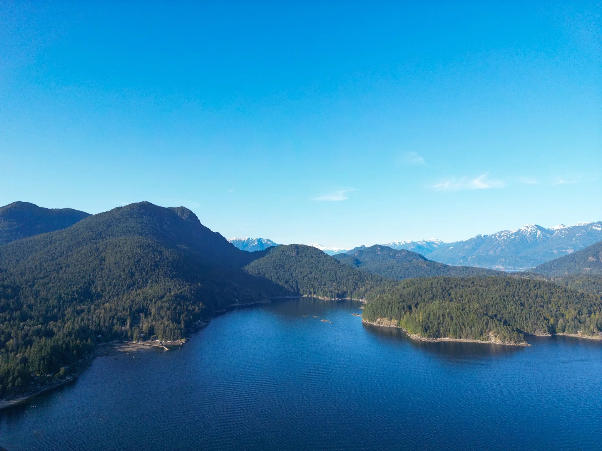
General Information About Gambier Island
Trail Map Credit:
Gambier Island Conservancy, 2024. Click the image for a full PDF.
Roads and Trails
There are gravel roads through many of the communities that do not connect up with other roads on the island. Of these, the largest network of roads is located around the westernmost peninsula of the island, encompassing the areas of New Brighton, Gambier Harbour, and the western edge of West Bay.
Outside this peninsula, the other Gambier Island communities have no road links to one another.
There is also a large network of many wonderful walking trails on Gambier.
A PDF trail map created by the Gambier Island Conservancy is available via a Google Drive link here or by clicking the Map photo. There are a fair number of undocumented, unmarked trails as well, and it should be noted that not all roads marked on this map or on BC Assessment exist, particularly around Hope Point.
A second excellent map I’ve come across is a 2018 map from the SCRD (Sunshine Coast Regional District). The SCRD map is particularly useful as it shows whether or not roads are developed, undeveloped, or forest service roads. A Google Drive link to this map is located here.
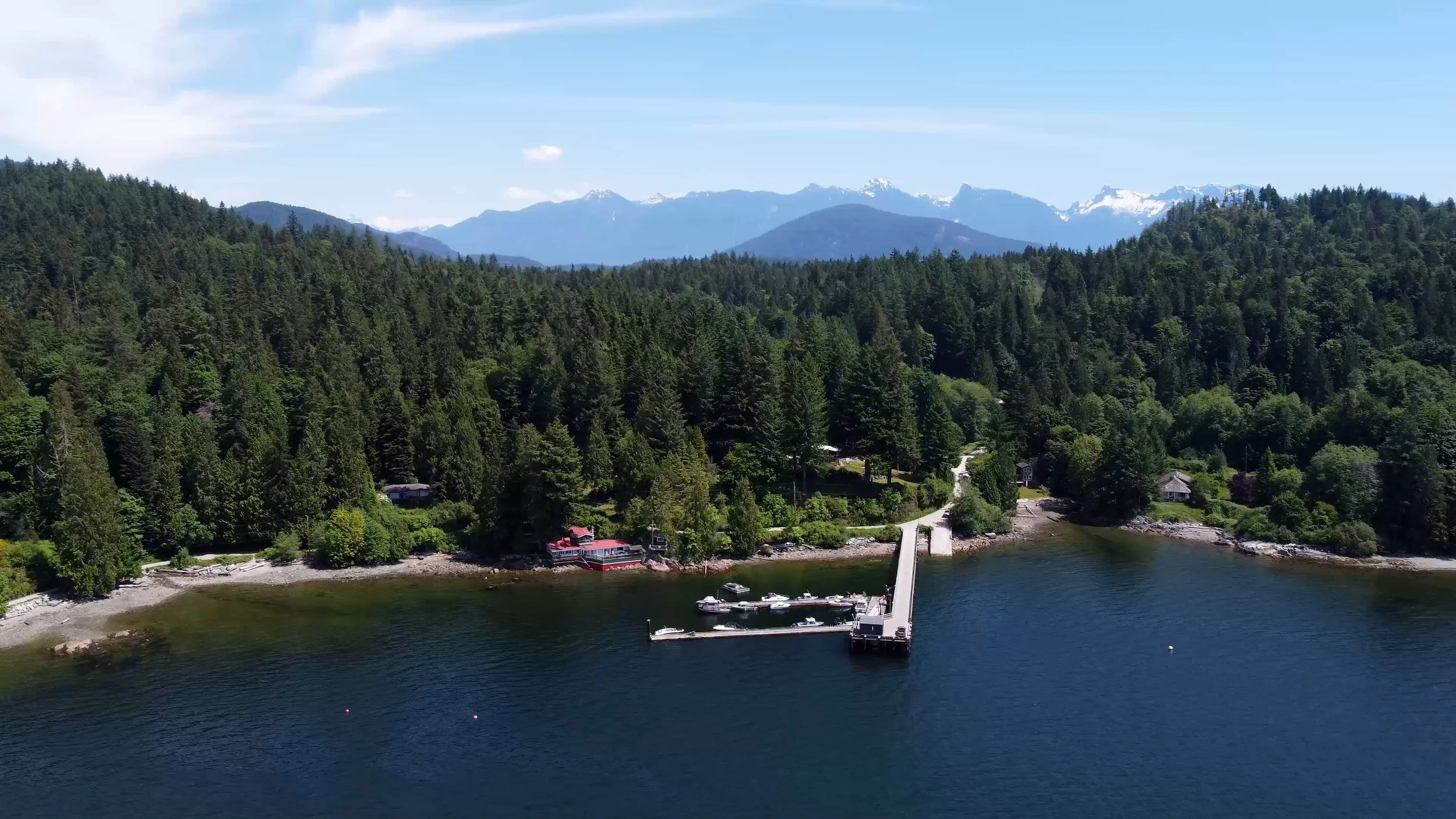
Barges & Barge Landing Areas
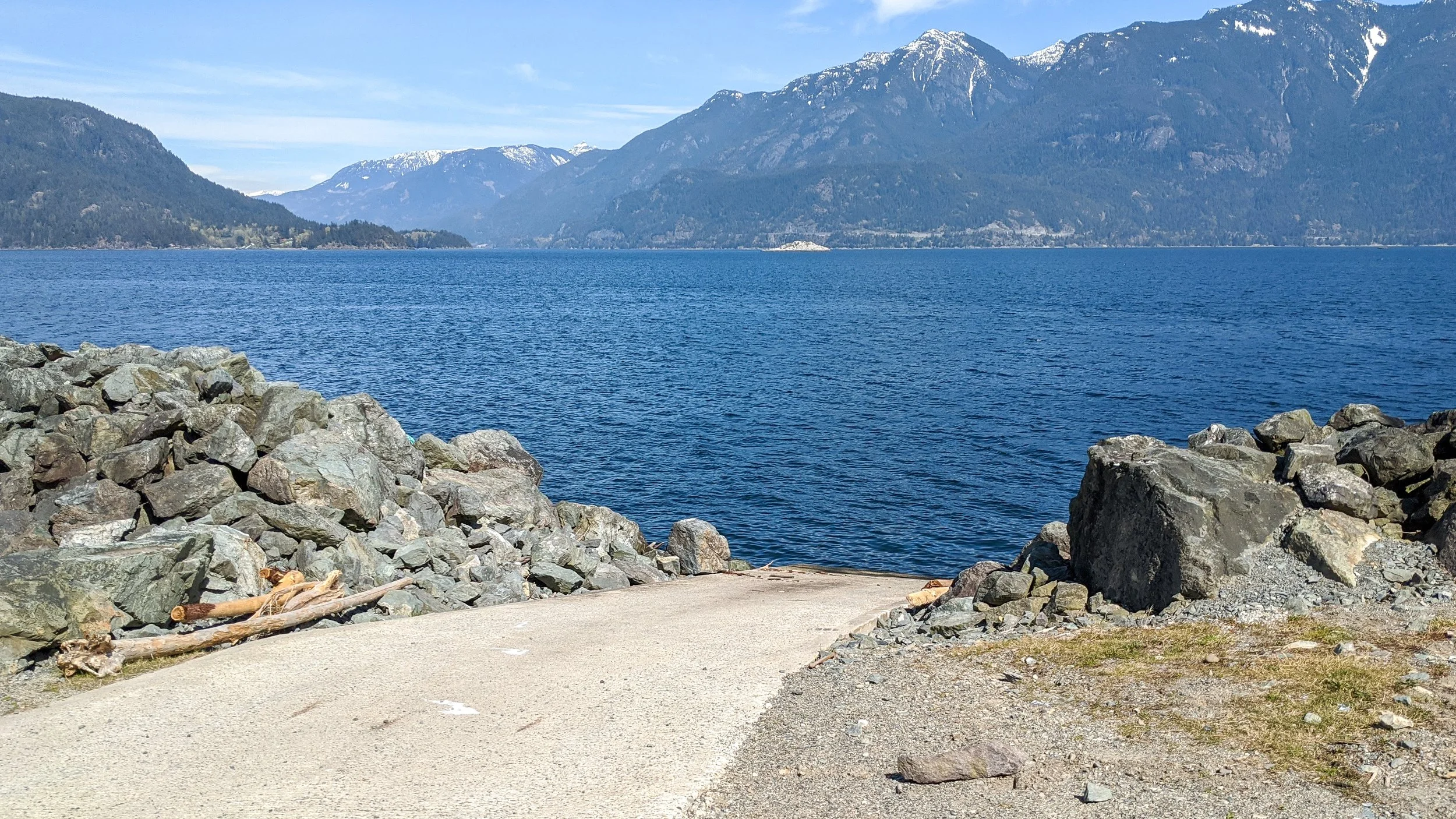
The barge landing area in Brigade Bay, 2025
There is no car ferry to Gambier Island, so if you want to get something on the island, such as a truck or building supplies, you'll need to hire a barge.
Most subdivisions have access to barge landing areas. These are extremely helpful, and building in areas without them creates significant challenges.
Building
I’ve written a secondary page about building, which can be viewed here: https://www.howe-sound.ca/building-keats-gambier-island
Mercury & Cormorant Scheduled Runs
Two of the water taxi companies operating in Howe Sound offer scheduled runs for fair rates of $35 to $37 per person. These boats generally go multiple times daily from Horseshoe Bay (and Sunset Marina as well for Cormorant) in the summer and on certain days in the winter. These can be an excellent way to get to the island without owning a boat, though these scheduled runs do not go to all areas of the island, operating only on the southern half of the island. It is also particularly helpful for friends and teenagers who want to join you at your cabin on a Saturday afternoon, rather than the whole weekend or week, without having you play chauffeur.
In the summers, both services frequently get full on Friday and Sunday bookings, and especially over sunny long weekends, so try to give at least 3 to 4 days’ notice to ensure you're still okay to book.
https://mercurytransport.ca/services/schedule-runs/
See also my section on the Stormaway to New Brighton.
Usability Of Your Acres, Privacy, Waterfront vs. Inland, & Deciding What’s Right
I have frequently seen clients tell me that a lot has to be 5 acres minimum or 20 acres minimum. I certainly understand that, in theory, more acres are better. That being said, I caution against becoming overly hung up on how many acres you are buying and rather focus on the privacy the lot provides and the frontage of the lot.
Square lots are typically far better than skinny rectangles. I’ve seen 100-acre properties which are not remotely private, and I’ve also seen 0.9-acre properties without a neighbour in sight (I purchased one of these myself). Waterfront properties in particular are often narrow and long, and realistically, you may only use the front 1/3 acre of the property.
So you need to ask yourself what you really care about. If privacy is the answer, you may wish to look more into inland properties. If taking a dip off the front of your property and seeing Orcas pass by is your key desire, then buy a waterfront property. Needless to say, everything is a tradeoff.
On Gambier Island in particular, many inland lots have great views and reasonable prices. I’ve seen many people wait until they have a waterfront budget, and miss many good years they could have spent happily on the island. You can always upgrade later, don’t miss happiness on Gambier just because 1 thing isn’t perfect.
Zoning
There are two primary types of residential zoning on Gambier Island. These are Settlement Residential (SR) and Rural Residential (RR). The zoning of both SR and RR is very similar overall, with the major difference being that RR also permits forestry, though in practice, virtually any lot zoned RR is only used as residential.
The following uses are permitted, subject to the regulations set out in this Section and all other uses are prohibited. a) Single family residential use; (b) Associated secondary dwelling use; (c) Domestic agriculture; (d) Agriculture; (e) Accessory uses including but not limited to home occupations.
Waterfront setback regulations are typically 15 metres, though there are some exceptions.
Both SR and RR properties allow for single-family home use plus an associated secondary dwelling, that is, presuming the property is over 0.4 hectares (i.e. 0.98 acres). Then for every 0.2 hectares larger than 0.4 hectares, you can build larger, etc.
Whenever buying with the intent to build more, always double-check the most recent Gambier Island zoning bylaws to ensure the lot you’re buying matches the zoning. I am happy to do this for you if I clearly know what your requirements are.
Fire Suppression & Emergency
Most communities on Gambier have some sort of fire suppression equipment, but no fire department. The level and scale at which the communities are prepared vary widely. Mostly, fire suppression equipment within Gambier Island communities consists of hoses for water cistern hookups and/or direct from the ocean pumps. Many communities also have critical medical supplies like AEDs, and some communities have helicopter landing pads for major emergency service calls.
I’d encourage you to look into this issue on a case-by-case basis. Just because there’s not much fire organization in a few communities, doesn’t mean it can’t be done.
Property Insurance
Property insurance is expensive relative to mainland homes, and far fewer insurance companies insure on Gambier. This is due to the lack of a fire department, coupled with wood stoves in most properties.
If the property you’re buying has a wood stove, you’ll likely need a WETT (Wood Energy Technology Transfer) certificate to get insurance. Most sellers will be able to provide you with them; if not, this can usually be written into your offer.
Prior to purchasing, I recommend you get a quote from an insurance broker. I am always happy to recommend an insurance broker for Gambier, even if you are not a current client/already own real estate on Gambier.
Cell Coverage and Internet Service
The southern half of the island mostly has cell coverage. I find that typically Telus is the best provider around Gambier, though it’s so close I wouldn’t switch providers unless you’re consistently not getting service on Rogers, while your friends are still connected to Telus. I cannot speak to Bell or other providers, as I have not personally used them. Once you get to areas like Brigade Bay and Douglas Bay, there is service from a few known spots in those communities, though there are certainly some dead spots, particularly in Douglas Bay. All around the island, many owners have boosters to improve service.
Internet service is typically via line-of-sight connections using Telus Rural Hub. The area around New Brighton, Gambier Harbour, and West Bay are currently in the process of getting fibre optic. Many residents also use Raincoast Networks, particularly around the Brigade Bay area. Starlink is also becoming increasingly common, though Starlink is pretty expensive, so I probably wouldn’t go this route unless living full-time in an area like Douglas Bay, which doesn’t get connections to the other providers. In many of the areas that get better cell service, many owners, especially part-time owners, are relying on cellphone hotspots for their only internet.
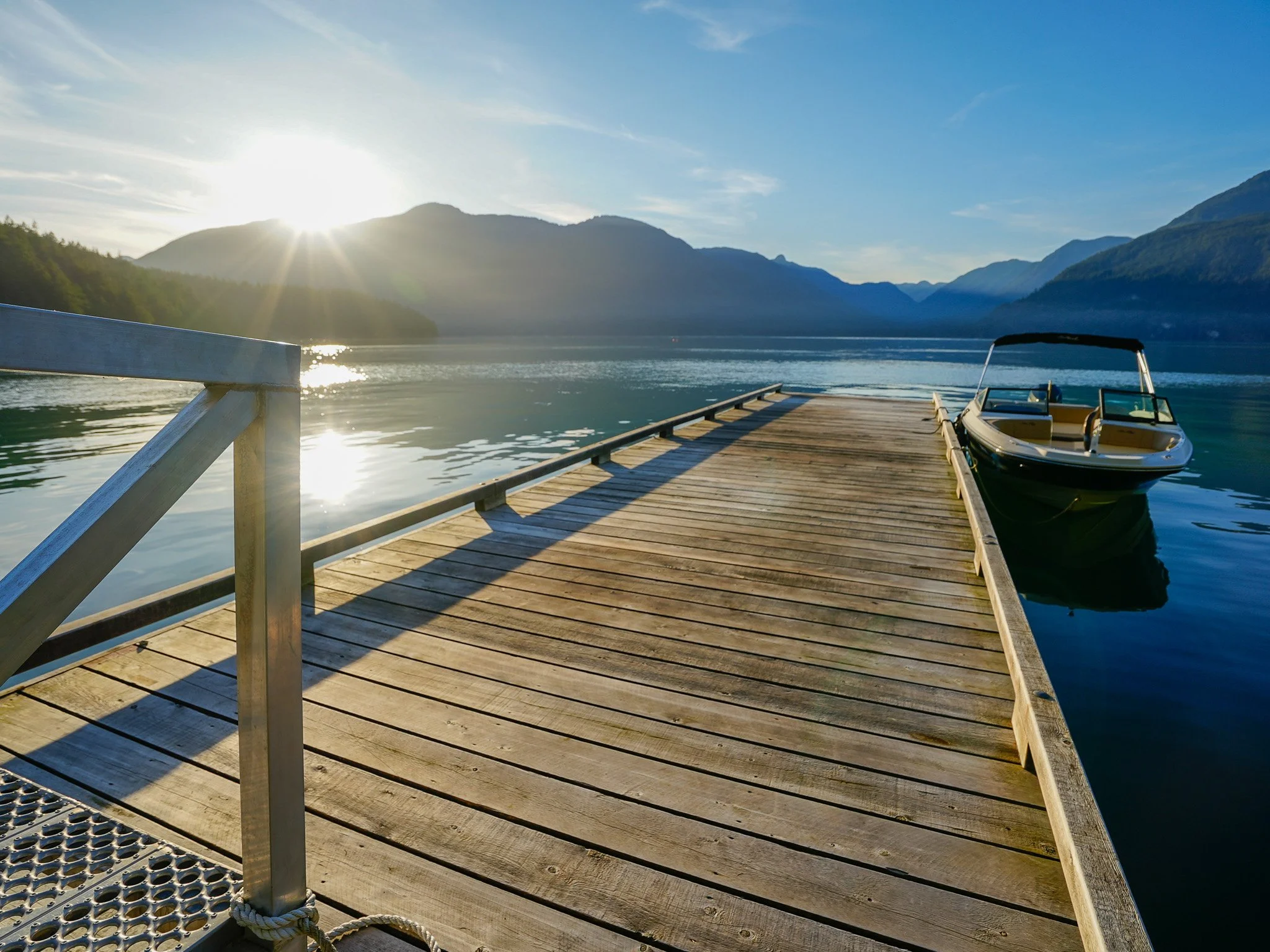
Marina Considerations
There are many marinas to choose from, most, if not all, of which will have waitlists.
Sewell's Marina https://www.sewellsmarina.com/about/moorage/ in Horseshoe Bay, Sunset Marina https://sunsetmarina.ca/howe-sound-mooring/, Lions Bay (dry dock storage up to 32ft) http://www.lionsbaymarina.com/drylandmoorage.html, Gibson's Marina https://gibsonsmarina.ca/, Squamish Yacht Club https://squamishyachtclub.com/, Squamish Marina https://www.squamishmarina.com/, Thunderbird https://thunderbirdmarina.ca/our-moorage-rates/, West Vancouver Yacht Club https://www.wvyc.ca/, Eagle Harbour Yacht Club https://www.ehyc.org/moorage, & West Vancouver Marina https://www.westvancouvermarina.ca/
A key way many of my clients get their initial moorage, at least to start, is to purchase a boat from the prior owner of the boat and transfer the moorage. Not all marinas will allow this, though a good number do. There are also many more marinas in False Creek, Coal Harbour, and along the Fraser River that are further by boat, though mean less time in traffic. Some of which can be viable options for more immediate moorage, while you wait for a slip to come up in a closer marina.
The Importance of Hiring A Real Estate Agent Who Knows Gambier Island
I’ve put this section in a little cheekily, as I’m referring to myself here. Though just as much because it is a legitimate consideration that shouldn’t be overlooked when either buying or selling. Gambier Island has a ton of island-specific considerations, and while this Gambier Island guide goes over a large number of these considerations, every piece of real estate on Gambier has such unique features, value propositions, and drawbacks that no two pieces can truly be compared head-to-head. I have physically stepped foot on almost all of the island’s recent sales, and almost all the sales going back nearly 10 years. This knowledge is especially useful when assessing market value.
One common issue is that the vast majority of the time, BC Assessment values are significantly off in either direction. I have seen several properties worth five times their BC Assessment value, and others worth less than a third. The main issue is that BC Assessment looks at the subdivisions as a whole, rather than the individual lot characteristics, which can differ greatly between neighbouring and nearby properties.
Population of Gambier Island
There is no one clear and correct estimate of the population of Gambier Island. There are a handful of estimates online, all of which seem a bit outdated from what I’ve seen. So I did my best to come up with a well-reasoned and researched estimate of the population. My estimate of the 2026 population of Gambier Island is 200 full-time residents.
Method as follows: the 2021 census reports the number of full-time residents within the Gambier Island Trust Area as 430 people (not to be confused with just Gambier Island). A key aspect of my reasoning that past numbers published on other websites are outdated is that between 2016 and 2021, the census population of the Gambier Island Trust Area grew from 247 to 430 full-time residents (Canada Census, 2021). The census refers to the area as the Gambier Island Trust Area, and the Islands Trust refers to this area as the Gambier Island Local Trust Area; I verified that this slightly different naming refers to the same area.
Most of the Gambier Island Trust Area has a largely part-time resident population, with the heaviest concentrations of people around Gambier Island, Keats Island, and North and South Thormanby Island. In total, the Gambier Island Local Trust Area includes 35 islands/islets, many of which are rocks, very small private islands, or sparsley populated islands: Alexandra Island, Anvil Island, Bertha Island, Bowyer Island, Christie Islet, Defence Islands, Echo Island, Franklin Island, Gambier Island, Grace Islands, Grant Island, Grebe Islets, Hermit Island, Home Island, Jack Tolmie Island, Keats Island, Little Popham Island, Merry Island, Mickey Island, New Islet, Pasley Island, Passage Island, Popham Island, Preston Island, Ragged Island, Shelter Islets, Small Island, Surrey Islands, North Thormanby Island, South Thormanby Island, Tiki Island, Trail Island, Turnagain Island, White Islets, Woolridge Island, and Worlcombe Island (Islands Trust, 2026).
I’ve based my estimates on my expert knowledge of this area, coupled with other estimates of past population: Gambier Island (~200 residents), Keats Island (~175), North and South Thromanby (~25), and all other islands combined, about 30 full-time residents.
Information from the Islands Trust indicates that in 2002, Keats had a population of between 50 and 80 full-time residents (Islands Trust, 2002/2023). The population has grown since then, coupled with increased access to the Internet and trends towards remote work, making island life more realistic. This is supported by the change in the 2016 to 2021 census reporting. Similar to the past Keats population estimate, an undated population estimate for Gambier lists 100 full-time residents as the population on Gambier Island (GambierIsland.org, 2026).
There is some argument to say that the population has decreased slightly since 2021 in the Gambier Island Local Trust Area, as it certainly swelled during the recreational covid-era property boom of 2020-2022, though that’s something to look for in the upcoming 2026 census results.
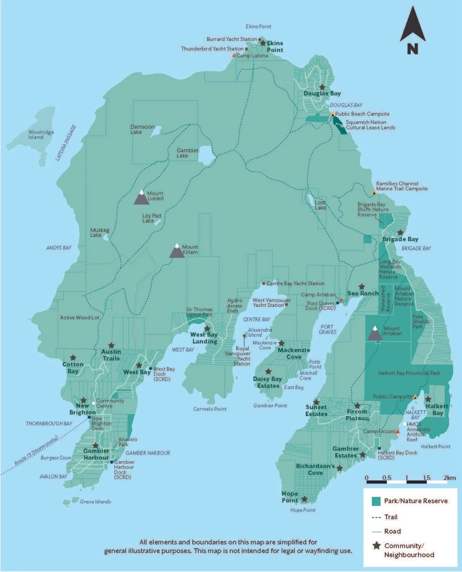
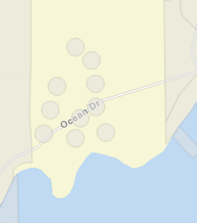
Neighbourhoods & Real Estate Subdivisions on Gambier Island (From West to East)
Modified map of Gambier Island (original from the Islands Trust) showing most communities listed. Click on the image to expand.
There are a handful of non-subdivided district lots not mentioned; many of these are designated forestry lots (on the north side) or are large private estates.
New Brighton, Gambier Harbour, and West Bay
I recommend the western peninsula of Gambier Island for almost anyone who does not want to own a boat, or who plans to use their property year-round, especially as a full-time residence.
This area is also the most densely populated on the island, with a long-established community making up approximately 80%+ of the island's full-time residents.
The BC Ferries Operated "Stormaway"
In part why this area is so great for year-round residents is due to regular service from the BC Ferries-operated passenger Stormaway. The Stormaway is a 30 to 40 passenger capacity water taxi that operates multiple times daily, between Langdale and New Brighton, including through the winter (albeit with a reduced schedule). The crossing is approximately 10 minutes.
Even if you wish to own a boat, this service vastly opens up your potential for use in the winter.
Prepaid adult tickets in 2026 are just $5.20 or $7.55 without prepaid tickets (+ the cost of the Horseshoe Bay - Langdale ferry if coming from that direction). Children $2.65 if prepaid, $3.95 without prepaid, for children aged 5 to 11. Free for children under 5.
Connected Power
Another key feature of New Brighton, Gambier Harbour, and West Bay is connected power with BC Hydro, something most of Gambier Island simply doesn't have.
Ownership and Lot Size
Nearly all of the properties on this peninsula are freehold ownership, though there is one section of desirable waterfront properties located just south of the West Bay government dock, which has cooperative ownership through "Lionsview Estates Ltd."
Lot sizes vary widely, with the smallest generally around 1/2 acre and the largest up to 10 acres; the vast majority are in and around 1 acre.
Community Centre and Farmers Market
In New Brighton, there is a small community centre, which hosts several community events throughout the year and can be rented out by residents.
Around the Gambier Harbour Dock, there is also a farmers’ market on Saturdays, which occurs from May to September.
Beaches
Each area has its own beach; most of the beaches around New Brighton, Gambier Harbour, and West Bay are relatively rocky beaches.
Kid Friendly & School Logistics
This area is wonderful if you have kids and want a spot for them to run around, get off their screens, and play with other kids. While there are kids in the other developments on the island, there are simply more friends to make in this area.
For year-round residents wishing to raise children on the island, Langdale Elementary School and Elphinstone Secondary School are easy options for children. There is school bus service for both schools picking up from the Langdale ferry terminal.
Bonus: children who are residents of Gambier Island ride the Stormaway for free when going for the purpose of school, or school-related events and sports.
In 2021, I filmed this video about New Brighton, Gambier Harbour, and West Bay. It includes some great visuals of this area.
Public Docks: The Drawback Of This Area (If You Own A Boat)
The majority of properties around New Brighton, Gambier Harbour and West Bay do not have private docks. Each of these areas have their own government dock, and many people have mooring buoys located around each of these docks for longer use.
The largest and only dock where you can keep your boat for over a week or weekend is located at New Brighton, and this dock is almost always at capacity or near capacity.
GFEG (Gambier Fire Equipment Group)
The most prepared of any of the communities is, of course, the largest one. There is a small fire truck located in this community, in addition to a number of fire equipment locations.
Property Values
Property values around New Brighton, Gambier Harbour, and West Bay tend to fetch higher prices than other areas of the island. This is particularly noticeable when comparing inland properties, where a non-view acre with a modest home is roughly in line with the price for 2-4 acres of waterfront with a similar home in Brigade Bay or Douglas Bay (both communities listed below), and 1 acre bare lot value is often comparable with a 5-acre parcel in Fircom Plateau. I'm not saying do not buy in this area, though DO think about how much you value connected power and the Stormaway service, as you are most definitely paying for it in your purchase price.
I also have a specific New Brighton Real Estate Guide, which goes into even further detail (linked here).
Austin Trails (i.e. the Mountain Road Properties)
Up the hill from New Brighton, and just east of Cotton Bay (discussed in the next section), is an inland subdivision of 15 freehold titled properties located on Mountain Road. These properties are between 3 and 6 acres. Like most of New Brighton, most, if not all, lots on Austin Trails are connected to electricity through BC Hydro. Notably, some of these properties have wonderful views.
While most people simply refer to this area as being in New Brighton, I make special mention as I have heard it called Austin Trails from time-to-time – most likely something to do with the original developer marketing of the subdivision. To further confuse matters, there is also an Austin Road close to the New Brighton dock, which is not part of this development.
Cotton Bay
Located a little north of New Brighton, there are 16 freehold properties in Cotton Bay. I’ve put Cotton Bay in a separate heading, as this development is tied to the roads around New Brighton, though it really feels like its own separate area and has some special considerations. The information regarding New Brighton, such as roads, schools, Stormaway, power, etc apply to Cotton Bay as well.
The waterfront properties, in particular, are desirable as they are low-to-mid bank lots facing southwest and west, all with great sunlight. The makeup of this subarea is a bit complex, as there have been at least 3 subdivisions over the years: an original dating back to at least the 1940s (likely earlier), another in the 1990s or 2000s, and a further subdivision in 2023.
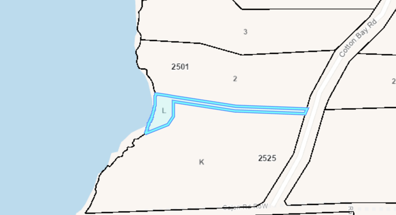
Lot L, the community lot. I believe Lot L is now technically owned by the SCRD, though I did not pull a property title to check.
All 16 connect to the road, 13 of which are waterfront, and 1 of the 17 properties is a community lot (the southernmost waterfront lot, Lot L, P.I.D. 032-611-129). The community lot includes a community dock off of it for roughly half of the properties. The developer disclosure statement
Given the barge landing area at New Brighton, getting building supplies to the properties is far easier than it once was, given the connected road access. All but one lot is connected to electricity through BC Hydro, or has electricity available to it at the lot line.
Note, not to be confused with an area on Keats Island called Cotton Point, which is its own development.
Zoning and Forestry Around Cotton Bay
A matter regarding Cotton Bay is mentioned in the Gambier Island community plan. Particularly, these lots cover District Lot 477, which, in the Gambier Island Official Community Plan Bylaw No. 73, 2001, Schedule B Land Use Designations, are listed as specifically not being part of Bylaw No.73. Rather, they are listed under ‘Bylaw 110’, which is a now-repealed bylaw; that is, other than Cotton Bay (as far as I can tell). The neighbouring lot, DL 5925, also fits in this same category, though is not part of the subdivision, merely the neighbouring lot to the subdivision.
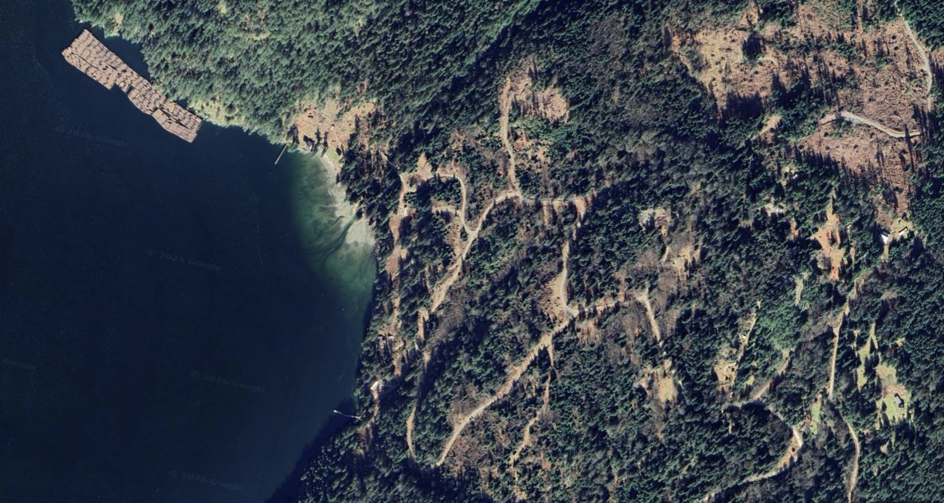
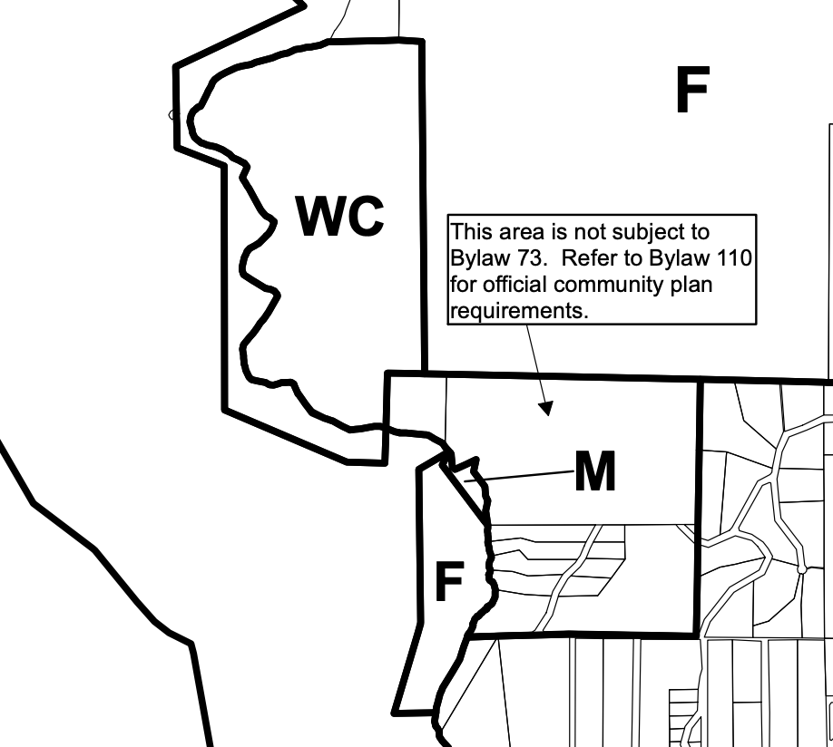
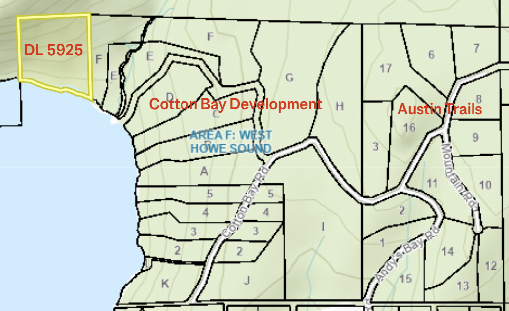
Most of New Brighton, West Bay, and Gambier Harbour is listed as Settlement Residential (SR), though this area still has Rural Residential (RR) zoning (i.e. it also allows for forestry use in addition to residential use). Why this matters is in relation to DL 5925 (which is a 10.2-acre lot I’ve indicated on the lot map). DL 5925 is almost like the orphan 17th lot in this development as DL 5925, has similar zoning, though really isn’t part of the subdivision as it wasn’t part of any recent subdivisions. There is also a forestry right of way along a road that runs through parts of the development, and in theory even provides some public access down to the water between lots D and E. In actual fact, it does not seem like there is yet a road down to the water through this Ministry of Forests right-of-way.
Ownership of DL 5925 may be under current forestry ownership, and while unlikely that this lot would be entirely clear-cut, it’s not out of the question that some of the lot could be used for forestry. Of course, more heavy forestry use would impact the real estate value of this beautiful south-facing lot significantly, and could impact the value of the neighbouring lots.
Further, there is forestry (F) zoning within the water area, which allows log booms to be situated almost directly in front of this development (obviously not ideal).
This is one of the few parts of the island where current forestry use is visible, due to Cotton Bay’s proximity to Port Mellon’s forestry operations. What is visible is the log booms to the north just outside of the development. In that location, there is usually a log boom present; log booms are also visible across the water on the Sunshine Coast side. All this being said, I boat by this area frequently and have kept on the section zoned F directly in front of the development, and I have not seen any log booms directly in front, or at least not within memory.
There is also a forestry-zoned lot directly to the north of Cotton Bay, which is presently used for forestry. Though this is not visible from any of the waterfront lots. I’d have to revisit some of the inland lots to see if it is at all visible from some of them, or potentially from the very backside of some of the waterfront properties.
West Bay Landing
In 2021, I created this short video, which I encourage you to watch if you’d like to see some visuals of West Bay Landing.
West Bay Landing includes much of the most coveted real estate on Gambier Island. There are many spectacular properties in this area, well-protected from the wind.
The naming of key elements of West Bay Landing baffles me. This is a distinct subdivision from the larger community in West Bay, located around the West Bay Government Dock mentioned in the section above. To further confuse matters, of the 48 waterfront properties in the subdivision, 19 properties are actually located on the west shore of Centre Bay, not West Bay. If that’s not baffling enough, some of the properties on the east side of West Bay have addresses on Centre Bay Road.
Connected Power
West Bay Landing has connected power with BC Hydro, something most of Gambier Island doesn't have.
Lots of Deep Water Docks + Communal Dock
Nearly all properties also have private deep-water docks. The subdivision also has 4 communal docks, 3 located in West Bay, and 1 located in Centre Bay.
Property Values
Part of West Bay Landing on Gambier Island
The properties on the West Bay side are generally the most valuable lots in the subdivision and some of the most valuable on Gambier Island. The lots on this side mostly face south, southwest or west.
That being said, many of the properties located on the Centre Bay side are also sought-after properties, many of which also have deep-water docks.
Ownership, Lot Size, & Homeowners’ Association
West Bay Landing was subdivided in the 1990s. All properties are freehold titled ownership. There is a homeowners’ association; which maintains the communal docks and roads. Last I checked, the homeowners’ fee was $1000/yr.
Mackenzie Cove + Mitchell Cove + Potts Point
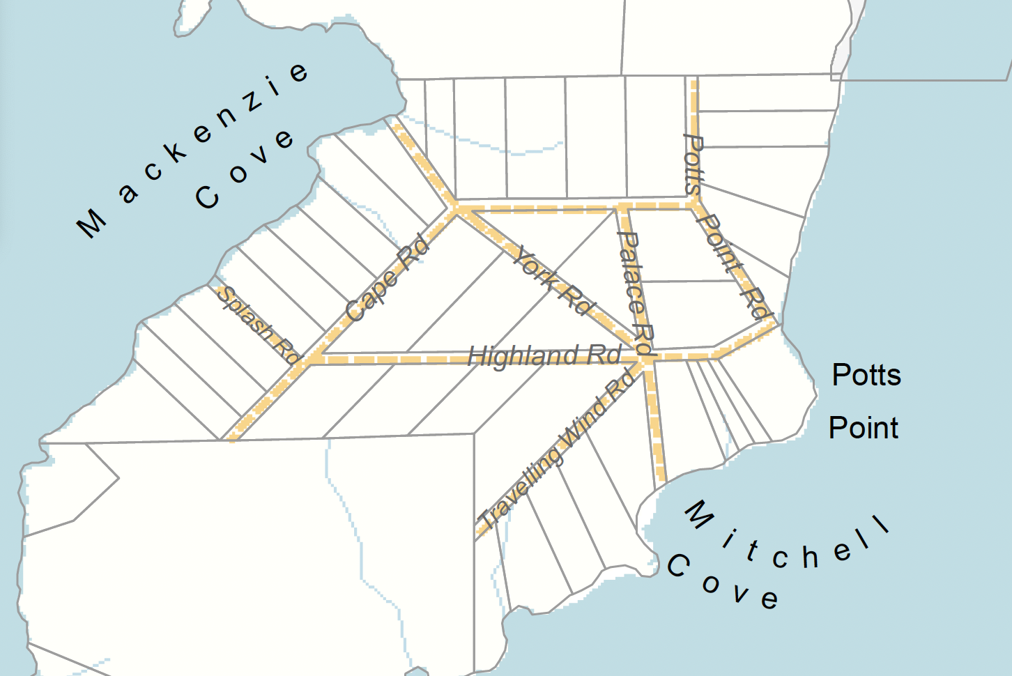
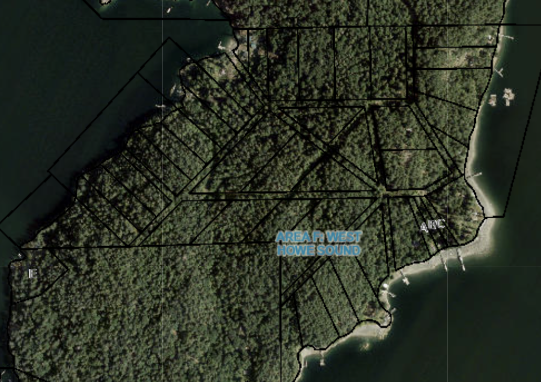
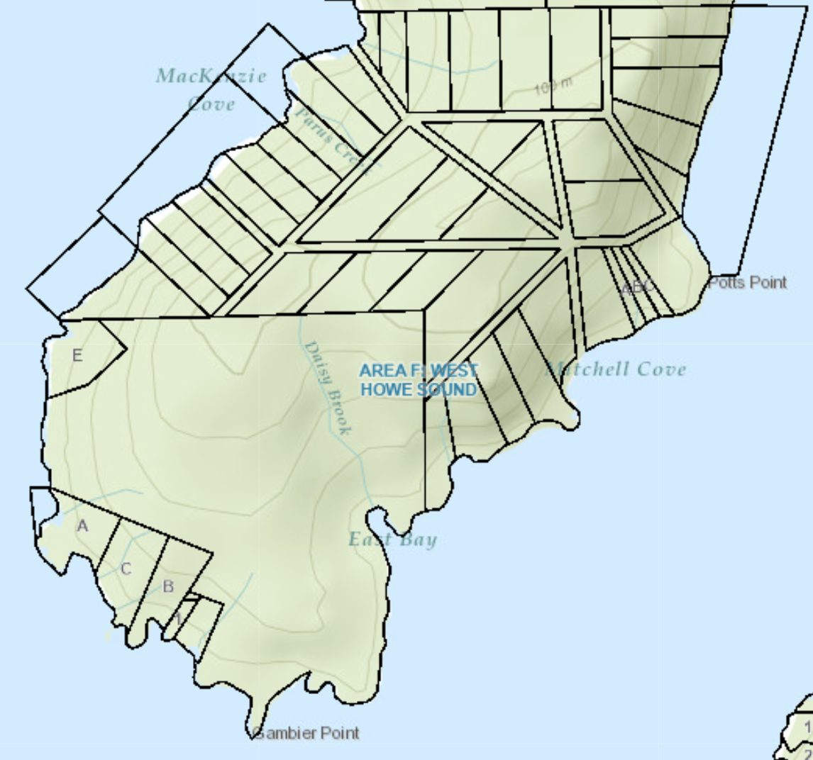
This section comprises a 42-lot off-grid, freehold subdivision, which includes: 11 waterfront properties located at Mackenzie Cove, 1/3 of the way up the eastern shore of Centre Bay; 15 waterfront properties fronting the western shore of Long Bay; and 16 inland properties on the peninsula between Centre Bay and Long Bay. While there are many individual property titles, to my knowledge, the ownership is held by a relatively small number of owners.
Several small roads are listed between the two sides on BC Assessment, though I can’t say I’ve actually seen a single road in the handful of times I’ve set foot in this area. A 2018 document I found from the SCRD also backs this up, showing undeveloped roads in this area. What’s odd is I can clearly tell from Google Maps that there is what looks to be a road going to Port Graves (over private land), plus several clearings that generally line up with some, but not all, listed roads in this area. They are likely not much more than old logging roads, though if someone with knowledge of this area could confirm, that would be helpful. This area does not have many sales, and so my knowledge of this area is far more limited than most areas on Gambier.
The west and northwest-facing properties in Mackenzie Cove fronting Centre Bay are extremely desirable due to their sun exposure, protectiveness to wind, and proximity to several yacht clubs in Centre Bay. I have yet to see an MLS listing in Mackenzie Cove or of the inland lots, nor do I expect to see one in the near future.
On the Long Bay side, there have only been two MLS sales over the last 10 years, occurring in 2016 and 2017. I am aware of at least one communal dock on the Long Bay side. Several of the lots around Mitchell Cove get morning sun exposure to the SE.
Other Long Bay Developments
Long Bay has a handful of subdivisions of various ownership types. There are also a handful of properties on the northwestern shore, that are not particularly tied to any one community. These should be investigated as they come up, as each will have unique features. Here is a quick overview of the communities in Long Bay.

Location of Daisy Bay Estates on Gambier Island (SCRD)
Daisy Bay Estates (a.k.a. East Bay)
Daisy Bay Estates is a cooperative on the southwestern end of Long Bay. Ownership covers 104.97 acres held by 10 shares.
Each lot represents a roughly 1.7-acre share in the corporation that owns Daisy Bay, particular to that property, as well as a common interest in the approximately 88-acres of common property. The common property is shared space for hiking and other outdoor activities. Most properties have their own docks, though there is a communal dock for access to some of the properties. Sales are rare; the last public sale to occur was Lot 8, which I co-listed in 2020.
Occasionally, I’ve heard Daisy Bay referred to as East Bay. Whether one calls it Daisy Bay or East Bay, the bay in question is a small cove within much larger Long Bay.
Gambier Point
This is really more on the Centre Bay Side, though this seemed like a good place to include, given its proximity to the neighbouring Daisy Bay Estates. Other than Daisy Bay Estates, 6 titles make up the tip of the peninsula between Centre Bay and Long Bay, all of which have highly desirable southwest-facing views.
Note on Camp Artaban & Port Graves
This isn’t a development per se, but a note on what is located at the northern end of Long Bay. There is Camp Artaban a family and children’s Christian (Anglican) summer camp. Port Graves is a government dock run by the Sunshine Coast Regional District.
Gambier Island Sea Ranch
At the northeastern end of Long Bay, there is also a strata subdivision called Gambier Island Sea Ranch. Over the years, several members of this subdivision have requested that I remove more detailed information from my website about the subdivision. To respect their wishes, I am not going into as much detail as in other areas on this list. Feel free to ask me directly about this subdivision and the properties listed within it.
Sunset Estates
Along the eastern shore of Long Bay is Sunset Estates, a subdivision that encompasses 13 waterfront, freehold properties, all of which have great views and excellent sun exposure. This is one of my favourite subdivisions on Gambier, as properties tend to fetch more reasonable prices than much of West Bay Landing
In 2021, I filmed this video about Sunset Estates, which includes drone visuals of this area.
Almost all of these properties are medium or high-bank properties, where topography can be challenging. I do not recommend these to anyone who has young children or mobility challenges. Most of these properties have private docks already.
There is a barge landing area for building supplies, and a communal dock meant only for temporary use to drop off your supplies for the weekend. This community is also tied in via community roads to Fircom Plateau, further down.
Listings are rare.
Hope Point Waterfront Developments
Depending on how you count, there are 5 or 6 distinct subdivisions around Hope Point. I’ve compiled summaries of the 5 smaller subdivisions into this one section. The 6th, Hope Point subdivision, The Gambier Estates, is listed under its own more extensive section just below due to several unique characteristics.
History of Hope Point, Gambier Island
Hope Point was one of the earliest parts of Gambier to be developed. There is an excellent article written by Sherry Cooper in 2006 about this history for the Journal of British Columbia Historical Federation (linked below). If Gambier’s history interests you, there is also a book, Miramar II: Gambier Island's History, published in 2011 by Bill Errico Jr.
DL 2704/387 Niagara Road, Hope Point
On the eastern side of Hope Point is a 66-acre collectively owned property (each owner registered as joint tenants). The property is split into 12 lots, applicable to select 4 to 5-acre portions of the 66-acres. There is a mix of waterfront and non-waterfront lots. The last MLS sale occurred in 2014.
The community owns a breakwater and a dock. Most of these properties have desirable southwest and west-facing views.
Sandy Beach Community
There is a mix of inland and waterfront properties centred around a sandy beach at the centre of the development. There are no roads that go between these properties, but there are several walking trails.
This is one of the oldest subdivisions on the island, first settled around the 1880s and subdivided into what it is today between 1906 and 1910. The subdivision encompasses 35 freehold non-strata lots, held by roughly 18 owners.
Most of the waterfront properties have private docks for access, and some owners also have mooring buoys. Many of the inland owners together co-own and share maintenance costs for a community dock.
There is a community water system and cisterns, servicing some, but not all, of the properties with water collected from a seasonal stream. Some owners also have their own wells.
Hjorthoys Orchard/Richardson’s Cove
Referred to as Hjorthoys Orchard (settled in roughly 1895 by Hugo Hjorthoy) or Richardson’s Cove, there are two distinct neighbouring developments. I am clustering them together due to the shared geography and very friendly nature of the communities. I will refer to these two developments as Gambier Acres Limited and the Parfitt Road Development.
As part of Hugo Hjorthoy’s legacy, there are around 50 heritage apple and pear trees still producing 1000 lbs of apples every year. As well, a previous owner in the Parfitt Road Development planted kiwi, fig, grape, mulberry, walnut, chestnut, and bay trees, and so many more odd things. My understanding is that these trees are present in both developments, though primarily around Parfitt Road Development (I could be wrong).
Gambier Acres Limited
Gambier Acres Limited is a cooperative with 10 shares located just east of the Sandy Beach Community.
The 10 shareholders own a plot of land encompassing 57.7 acres, with the building sites all situated close to the water. Roughly half the potential sites have been developed at this time. Shares apply to building sites, which are 10,000 sq ft each, plus the share in common property. All properties are off-grid.
The community has its own water system and common dock.
Parfitt Road Development
Screenshot from BC Assessment showing the lower part of 330 Parfitt Road, Gambier Island
By far the most unusual development on Gambier is an off-grid, 10-lot bare land strata development located at 330 Parfitt Road. This is just east of Gambier Acres Limited. Building sites are listed as individual lots on BC Assessment, and each lot is a 100 ft diameter circle (BC Assessment lists size as 7,840 sqft).
This development encompasses roughly 55 acres subdivided in the late 1960s or early 1970s, as part of “cluster housing”, a similar concept that saw the development of False Creek south.
The strata community has a well, a common dock, and a shared common cabin.
The Gambier Estates
The Gambier Estates, not to be confused with Gambier Acres Limited (discussed above), encompasses approximately 27 off-grid properties covering 31 lots, located near the water, to the east of the Parfitt Road development, down from the Fircom Plateau subdivision and slightly west of the Halkett Bay Dock. About half the properties are waterfront, and half are just off the water, though have easy beach access.
There are many exceptional south and southeast-facing views from the waterfront properties, and due to the relatively gradual incline of the land behind, they also have significant sun exposure well into the evening. Many of the non-waterfront properties also have good views.
Private Docks
Currently For Sale: 671 Bowen View Road within the Gambier Estates
Most waterfront owners access their properties by private dock.
Connected Road To The Halkett Bay Dock/Barge Landing Area
Bowen View Road, aptly named, connects the neighbourhood to both the Halkett Bay Dock/barge landing area (see section under Fircom Plateau writeup). That connection matters as it is key for all construction logistics and for owners who do not have a private dock. It is also important in the event of a fire.
Ownership and Lot Size
Similar to the Hope Point subdivision, this is one of the oldest subdivisions on the island, dating to the early 1900s, though most properties have since been rebuilt.
All lots are freehold title ownership. A community fee of $300/yr helps with roads, water, or anything that’s required, though it is not a strata, and as far as I know, it’s not even a proper homeowners’ association, but rather owners getting together to improve their community.
Properties vary in size from about 13,000 sqft to several acres.
Community Water System
The Gambier Estates has a non-potable community water system (made up of surface water, plus 2 wells). Filtration is done by individual owners on their own properties.
Fircom Plateau
Fircom is one of the most affordable developments on Gambier Island, containing 60 inland properties.
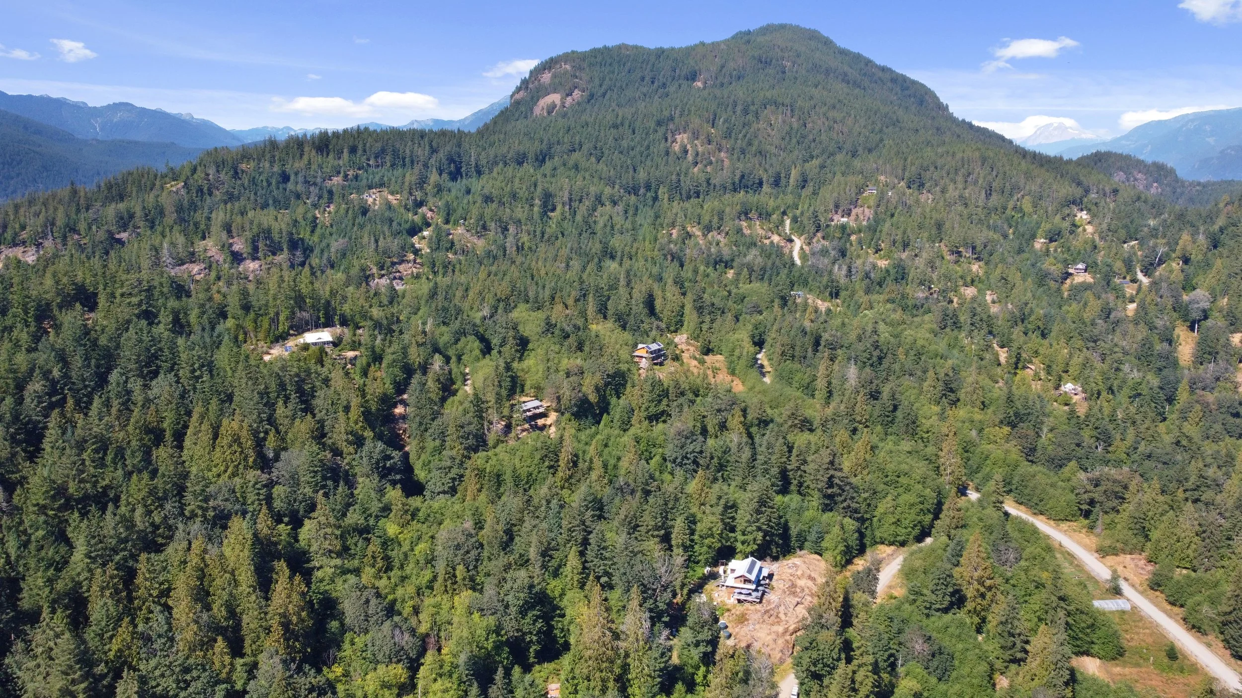
Fircom Plateau, 2022
What I really love about Fircom is the general vibe of this community. As Gambier Island’s newest major subdivision (2006-08), it has a more active community of owners than many on this list. Fircom is a place where many owners are still building and strategizing together how to further improve their getaways, given the more entry-level prices, there are also far more owners building their own fairly basic cabins.
Another thing I love about Fircom is that it is both the first and last stop on Mercury’s scheduled runs, saving significant time on their scheduled water taxi run in either direction. So, for accessibility without actually owning a boat, this is very high on the list.
All properties are fully off-grid, each with its own drilled well.
Topography and Views
Topography varies a lot here, where there are some near flat lots and some steep lots. The steep lots are often more desirable to buyers as they tend to be the ones with better views. Including expansive views towards Bowen Island, Hutt Island, glimpses of the Georgia Strait, Keats Island, and some views of the North Shore mountains.
Some of the flatter lots can be excellent for those who desire large gardens and/or wish to have chickens and goats. Even lots side by side properties can vary widely in terms of their topography and views.
Ownership and Lot Size
All properties are freehold titled ownership, all of which are approximately 5 acres.
This subdivision also has a homeowners’ association. Depending on when the property was originally sold, some properties have a requirement on their property title to be a member of the owners association and others do not. As far as I know, this was an oversight. That said, I highly recommend all owners join the association whether or not they are legally required to. The association helps maintain the communal roads in the subdivision and is adjoined with the ownership of the dock at Sunset Estates (different name, but also part of the same owners association). Unlike a pesky condo strata council or demanding HOA in a golf course community, this homeowners’ association is simply for the good of all owners without major restrictions on what you can and can’t do on your property. Last I checked, the cost was $500/yr.
Halkett Bay Government Dock (a.k.a. Fircom Dock) & Mooring Buoys
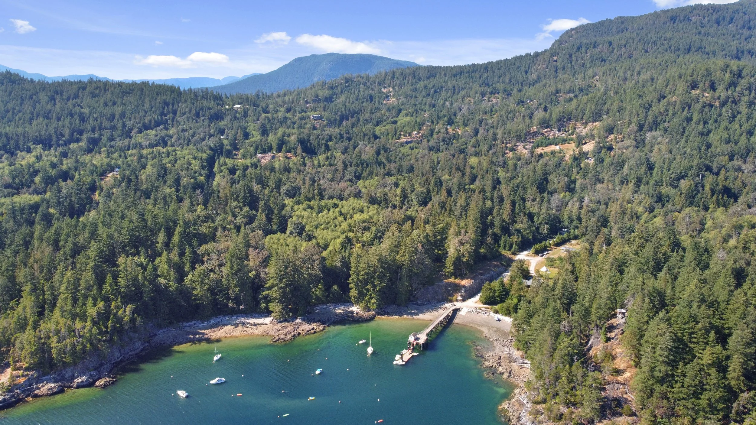
Halkett Bay Government Dock (Fircom Dock), seen in 2022 (not much has changed since the image was taken).
There is a public government dock located at the base of the subdivision, renamed in 2024 as the Halkett Bay Dock, though often still referred to as the Fircom Dock. This is also the same dock that the water taxis will drop off at.
The scheduled runs through Mercury and Cormorant are so good and affordable that I recommend using the water taxis for your primary source of access if purchasing here. The water taxis scheduled runs are easier than a private boat, cheaper than a private boat, and more reliable than a private boat. That is, unless you just really want a boat, which I can totally understand!
A dinghy located on this dock allows owners somewhat easy access to the many mooring buoys. Many lots already have a mooring buoy they use, and there really isn’t much room for any more. If you’re taking over a mooring buoy, remember to check the chains post purchase.
Just up from the dock, most owners park worn-down old trucks or side-by-sides for access to their properties.
Maximum time of moorage at the public dock is 24 hours, though it is considered common courtesy to only leave your boat on the dock for a few hours at max/drop your stuff and put your boat on your mooring buoy.
Barge Landing Area
Just off the Halkett Bay Dock is a barge landing area for moving larger materials and getting vehicles to the island.
Halkett Bay
Halkett Bay is home to Gambier Island’s only Provincial Marine Park, encompassing much of the SE tip and easternmost bay of Gambier. Tucked into the bay’s east shore, there are 9 exceptional west-facing properties. Several of the properties have private docks, and there is a communal dock servicing the remainder.
It is a truly gorgeous area of the island, and for most of the year, the marine park is not widely utilized. That being said, most summer weekends attract fairly significant number of boats to the marine park, both overnighters and for day use. Like any marine park, about 95% of the users quietly enjoy the park, though about 5% run loud generators at midnight and/or think everyone shares their taste in music.
Like Fircom, Gambier Estates, and Hope Point, the proximity to most of the West Vancouver marinas is a big plus.
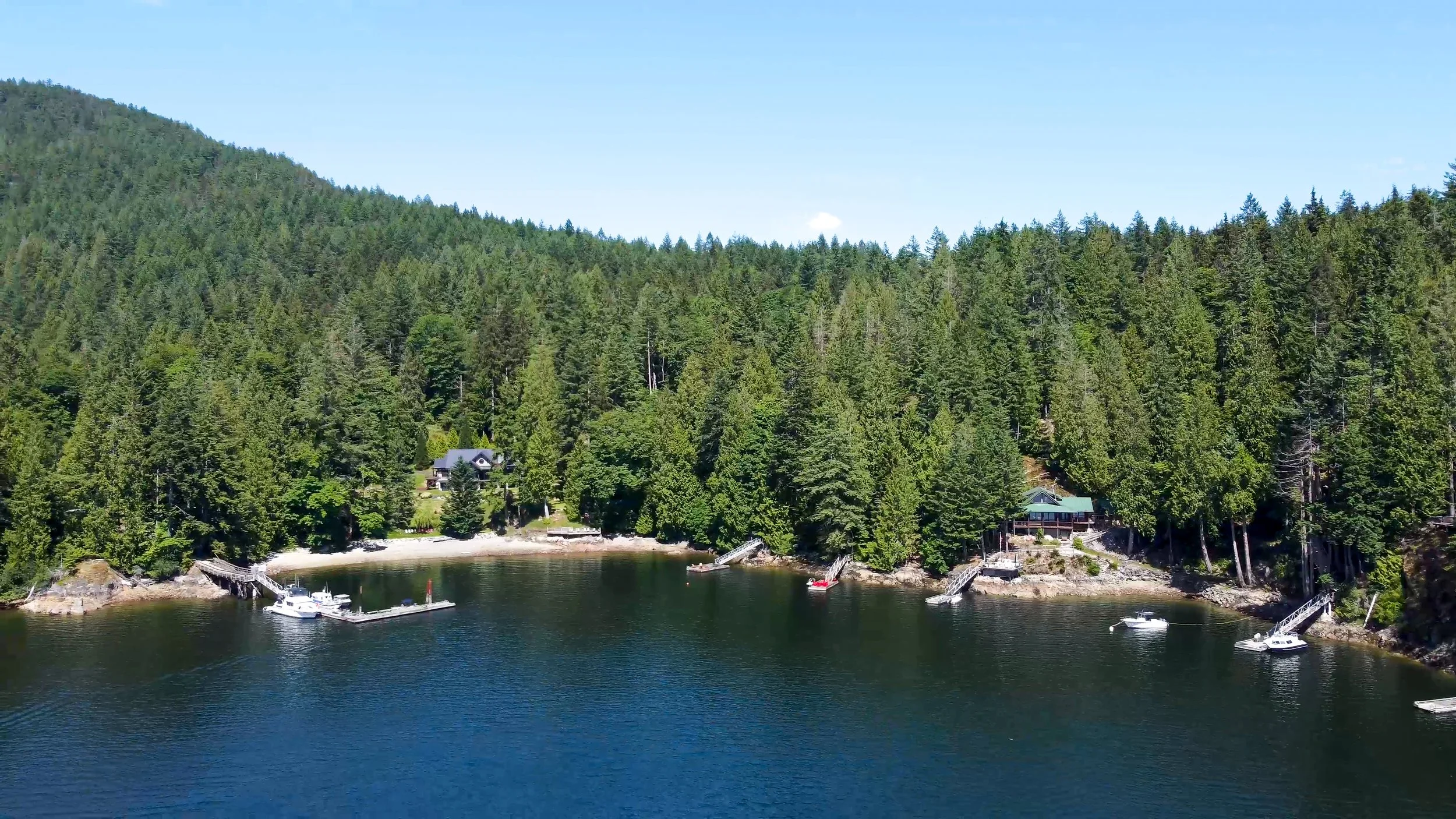
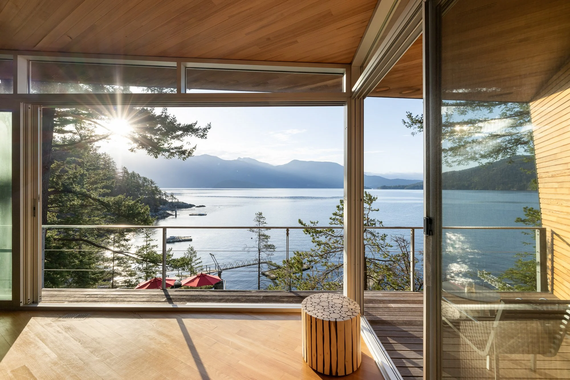
Brigade Bay
This 68-lot, off-grid subdivision is halfway up on the eastern side of Gambier Island and is my favourite subdivision on Gambier Island. I highly recommend this subdivision if you wish to use your property seasonally and/or are new to boating. I also find the value of what you spend vs. what you get to be the best value proposition on Gambier and within Howe Sound.
Ownership, Lot Size, & Homeowners’ Association
All lots are freehold title ownership.
The smallest lots are about 1.7 acres, with many in the 2-10 acre range, plus several over 10 acres. In Brigade Bay, I wouldn’t focus too much on how many acres you are getting, but rather the usability of the acres you have. Some of the smaller 1.7 to 3-acre lots may have more usable acreage than many of the larger lots.
All lots in this subdivision are waterfront, though in the case of a handful of the high-bank lots, access to the water from the property itself is not simply possible due to the steepness of the shoreline.
The Brigade Bay community is run by a homeowners' association that covers the costs of basic community fire equipment, marina/dock & breakwater maintenance, and road work. Similar to Fircom listed above, unlike a pesky condo strata council or demanding HOA in a golf course community, this homeowners’ society is simply for the good of all owners. There are some restrictions on what you can and can’t do on your property, so I recommend you double-check the bylaws and zoning before purchasing. 2025 annual fee $1,245/yr.
Brigade Bay Marina and Breakwater
There is a private community marina for the owners of Brigade Bay. There is no additional cost to use the marina other than your yearly homeowners’ association fee.
Several restrictions should be noted: maximum boat length overall is 27’, and with a maximum beam of 8’6”. Additionally, the marina is not meant for long-term moorage of boats when owners are not currently at their property, something I’ve frequently been asked about.
While many prospective purchasers want their own private dock, having the communal marina is realistically far less hassle. The zoning in Brigade Bay does not allow owners to have private docks, other than some allowance for temporary summer floats.
Brigade Bay owners park worn-down old trucks at a parking lot located just up from the marina for access to their properties.
Brigade Bay’s Specific Zoning
Brigade Bay is different from most subdivisions on this list in that this area has some subdivision-specific zoning, in addition to the general RR (Rural Residential) zoning covered in the General Information section of this post.
Screenshot of the trail between Port Graves, Long Bay to Brigade Bay.
Click on the image to enlarge.
Credit: Gambier Island Conservancy, 2024
Proximity
Simply, the distance to Brigade Bay is shorter and generally calmer in the late Spring, Summer, and early Fall than the south end of the island. Winter weather coming from Squamish can make boating in this area more challenging in the winter, though generally speaking, boating to Brigade Bay from April 1st to September 30th is fairly smooth sailing.
Surprisingly Good Sun Exposure
Brigade Bay should not be overlooked due to assumptions of sun on east-facing lots. Due to the topography of the island and a noticeably flat section located around the north-eastern end of Long Bay, many of these mostly east-facing lots in this subdivision get significantly better sun for about 6-8 months of the year than many other areas of the island.
Trail Between Port Graves and Brigade Bay
Going from Port Graves in Long Bay to Brigade Bay, there is a walking trail. Some buyers, but not all might be consider this feasible for regular property access to Brigade Bay (depending on where your property sits and your fitness level). Port Graves is accessible via the water taxi scheduled runs (see section on this above), and isn’t geographically far from Brigade Bay. I haven’t personally walked this trail myself, though I hear it takes about 30-45 minutes.
While there is another trail going from the Halkett Bay Dock (a.k.a. Fircom Dock) and Brigade Bay, through Halkett Bay Provincial Marine Park, I wouldn’t call this trail very realistic with a load of supplies for a week or weekend away.
Douglas Bay
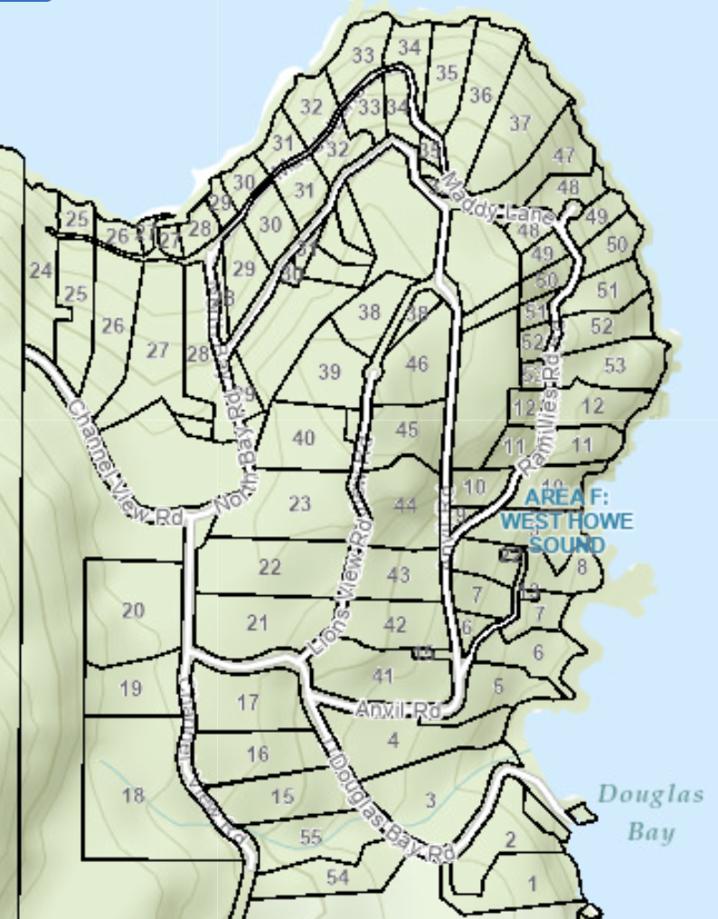
The Douglas Bay Subdivision. Screenshot from SCRD Maps.
This 53-lot, off-grid subdivision is located at the northeastern tip of Gambier Island. Douglas Bay is a highly unique part of the island and a great spot to own real estate, particularly if looking for a part-time and/or seasonal cabin.
I encourage you to read my section on Usability Of Your Acres, Privacy, Waterfront vs. Inland, & Deciding What’s Right listed under General Information if you haven’t already, as there is no development on Gambier Island that this applies to more than Douglas Bay.
Ownership, Lot Size, & Strata Corporation
All properties have freehold strata titles. The strata fee is $1,300/yearly, which covers road maintenance, common dock upkeep, and any other community projects.
Property sizes vary quite widely, with the smallest lot around 1.8 acres to the largest around 9.9 acres; the vast majority of the options are in the 2.1 to 3.9 acre range.
Topography Creates Many Choices In Douglas Bay
One thing that makes Douglas Bay so unique is the contrast between the properties. No two properties are the same or very similar.
A handful of the inland properties have absolutely exceptional sweeping views out to Anvil Island, Pam Rocks, Bowyer Island, and much of Howe Sound. A couple of inland lots have incredible views toward McNab Creek/Valley, capturing unreal sunsets and, at the right time, the Aurora Borealis. Many of these inland properties are reasonably affordable, often in and around $250,000 to $300,000.
Amongst waterfront properties in the development, there is also a wide mix of options. Lots 1 and 4 on the eastern shore have direct low-bank beach access. Lots 5-10 usually have the ability to get down to the water in rocky outcrops. As you get to the far NE point of Gambier you see sweeping views southeast (Lots 11 and 12) as you come to the bend.
The higher banked waterfront properties facing east (Lots 47-53) have great privacy from each other and from the passing boats; these have some great views of the coolest cliffs in Howe Sound on Anvil Island. I quickly feel calmer when I’m visiting these properties.
The corner itself is exceptional with wide views from NW to NE (Lots 34-37). Then most of the back waterfront properties face NW (Lots 28-33), getting wonderful sunset views, great late afternoon sun, and stunning views of McNab Creek. Going around the northern bay of Gambier toward Ekins Point, the remaining Douglas Bay properties face NE (Lots 24-27) towards the nearly always calm backside of Gambier Island, a water skiers’ paradise.
Docks, Buoys, and Barge Landing
There are 2 common docks, located near Lot 2 and Lot 28, both of which service properties in those areas and the inland lots. There is also a barge landing area near Lot 2, the southern part of the development, which is available to all Douglas Bay property owners. Several mooring buoys exist around both communal docks for busy summer weekends when the docks may reach capacity.
There are also 2 exclusive docks, off Lot 9 and Lot 50, which service the properties directly around those two smaller docks.
The maximum boat length overall is 25’ at all the strata’s docks.
Options For Private Dock
In addition to the communal docks and exclusive community docks, many waterfront owners have private docks. There is a mix of unpermitted docks and docks with proper foreshore leases.
Water and Septic
For water, all properties have drilled wells. All properties also have a designated location for a septic field, though many owners end up placing their septic field elsewhere.
Cell Service
Most of Douglas Bay does not have cell service, though it is possible to get a connection from the very highest parts of the development. Some owners will drive their trucks up to the top of the hill once or twice a day for a quick connection, before going back to their off-grid, offline relaxation time.
It shares many characteristics with Brigade Bay, though Douglas Bay is distinctly its own thing.
Ekins Point
There are 3 freehold properties zoned RR (Rural Residential) around Ekins Point. These are located amongst several yacht clubs: West Vancouver Yacht Club, Thunderbird Yacht Club, and Burrard Yacht Club. One was for sale in 2018 and was eventually sold in 2020. I am unaware of any information regarding communal docks, water systems, or septic systems in this area, though